Ostia-Portus, hub of the Roman Empire
This programme is dedicated to the memory of Mireille Cébeillac Gervasoni, who died on March 29, 2017. A long-time researcher on Ostia, she participated in its development with her well-known enthusiasm and dynamism.
- Section: Antiquity
- Directors: Evelyne Bukowiecki from the École française de Rome; Simon Keay from the University of Southampton – British School at Rome; Nicolas Laubry from the École française de Rome; Gloria Olcese from the University of Milan; Renato Sebastiani, from the Soprintendenza Speciale for the Colosseum and the central archaeological area of Rome; Catherine Virlouvet, from the University of Aix-Marseille-Centre Camille Jullian ; Fausto Zevi, Sapienza University of Rome and Accademia dei Lincei.
Presentation
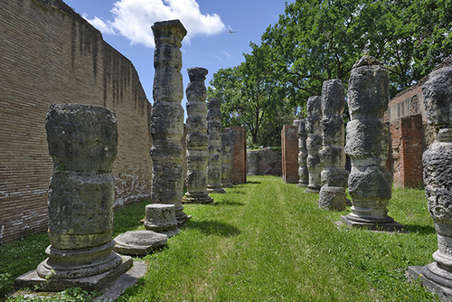
Located at the gates of Rome, at the mouth of the Tiber River, the Ostia-Portus port complex is the largest in the ancient world. By its proximity to the capital of the Empire, its strategic position along the Tyrrhenian coast and its rich network of navigable canals, it can also be considered as a real hub of the Roman Mediterranean.
We already well understand its central importance for the supply of the Urbs between the last centuries of the Roman Republic and the end of Antiquity, but there is still much to learn about its own life: the population who lived there, its relationship with the hinterland, its links with the rest of Italy and the Mediterranean world, the products that passed through it, the mechanisms of redistribution to and from Italy, the construction sites of the port facilities, safety measures in seaports, etc.
This new programme intends to shed light on the composition, the functioning and the daily life of this port society, on which we have a wealth of information largely unexplored. It will revolve around three main objectives:
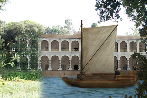
Complete our knowledge on the construction and operation of the port complex through targeted field operations (test trenches, surveys and graphic reconstructions) around a collaboration between international teams working on the Portus site who will seek to set up a unitary research protocol (planimetry, 3D modelling, catalogue of stamps on bricks, etc.).
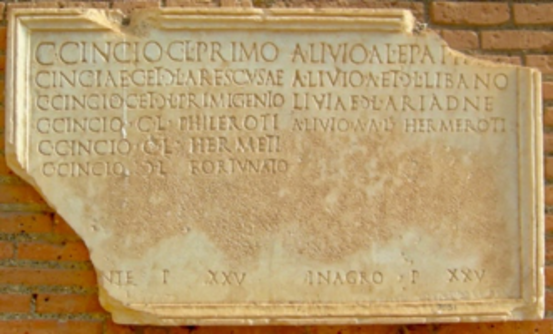
Form a better understanding of the society and administration of Ostia-Portus by providing researchers with rich archives of past excavations and unpublished inscriptions from the two port sites.
Analyze long-term commercial flows based on an analytical study of the ceramic material from excavations in ancient Ostia, its territory and its surroundings.
Key words
Roman antiquity, Mediterranean, Italy, port, commerce, population, ceramics, harbour architecture, Ostia, Portus
Key statistics
- 5 research teams
- 2 port sites
- 3 km: distance between Ostia and Portus
- 60 hectares: accessible area of ancient Ostia
- 150 hectares: estimated total area of ancient Ostia
- 32 hectares: accessible area of Portus
- 65 hectares: estimated total area of Portus
Links for more information
The links here to information or publications (on paper or online) are connected to the programm or directly related to it.
- Book : 2018
- Articles : 2018 ; 2014
- Excavation campaigns of Ostie-Portus in the "Chronique des activités archéologiques de l'Ecole française de Rome
- Seminario ostiense: 2018
- Scientific blogs: Romatevere ; Cirili
- Videos: 2019
- Others links: Parco Archeologico di Ostia Antica; Portus Project; Portus Limen; Immensa Aequora; Navigare il territorio
Calendar
Réalisations depuis 2017
- Deux campagnes de fouilles sur le môle nord-sud de Portus (automne 2017 et 2018) ont été conduites par Evelyne Bukowiecki et ont permis d’accueillir une quinzaine d’étudiants notamment de La Sapienza Università di Roma.
- Deux campagnes de fouilles sur la villa A de Dragoncello (automne 2017 et 2019) ont été conduites par Gloria Olcese.
- Une field school d’initiation à l’archéologie a été organisée par Simon Keay dans la zone au nord des entrepôts dits sévériens (été 2017)
- Deux campagnes de relevés photogrammétriques sur les entrepôts dits sévériens (printemps 2017 et 2018) ont été réalisées par Steve Kay (BSR).
- Deux « Seminari Ostiensi » sur l’activité des recherches à Ostie et Portus ont été organisés en février 2018 et avril 2019, réunissant à chaque fois une quarantaine de chercheurs pour une vingtaine de contributions.
Programmation 2020-2021
La programmation de la recherche sur Ostie-Portus s’est enrichie de l’intégration dans le projet « Fos-Ostie-Portus. Harbours of Roman Antiquity » (FOSPHORA) financé par la fondation A*Midex d’Aix-Marseille Université (80 000€ obtenus dans le cadre de l’appel à projets « Méditerranée »). Ce projet, mené en partenariat avec plusieurs laboratoires CNRS d’AMU (CCJ, CEREGE, TELEMMe) et les institutions régionales en charge du patrimoine travaillant sur le port antique de Fos sur Mer (avant-port d’Arles), ambitionne de comparer les structures portuaires de ces deux très grands complexes de la Méditerranée occidentale, présentant à plus d’un titre des problématiques communes : situés tous deux à l’embouchure d’un fleuve, reliés à leur arrière-pays par un réseau articulé de canaux, ils entretiennent des liens complexes avec les villes portuaires et commerçantes qui les environnent (Arles mais aussi Marseille pour Fos, Rome pour Ostie-Portus). Le séminaire de lancement se déroulera à Aix-en-Provence début 2020.
Les opérations suivantes viendront enrichir tant le programme Ostie-Portus que le projet FOSPHORA :
- Synthèse des données géo-morphologiques acquises sur les deux sites d’Ostie et Portus avec intégration des carottages effectués dans le SIG du Parco Archeologico di Ostia Antica GIS_MONDI. Cette synthèse aboutira à la publication fin 2020 d’un gros article dans les MEFRA.
- Prospection géophysique pour la localisation du tracé du « canale drenante » dans le bassin de Claude et réalisation de 2 à 3 carottes au niveau de ce canal et du canal longeant la côte entre Portus et Ostie.
- Dépouillement et recollement des archives cartographiques et intégration dans le GIS Mondi du Parc archéologique d’Ostie.
- Réalisation de deux autres campagnes de fouilles dans la zone du môle de Claude en connexion avec le Portique de Claude où affleurent les structures d’un petit édifice thermal inédit, en collaboration avec Grégoire Poccardi (Université Lille 3 – AOROC).
- Réalisation de 3 carottages dans la structure des 3 phases de construction du môle nord-sud pour mieux comprendre la profondeur et le type de construction du môle original et de ses deux extensions (sévérienne et tardoantique).
- Réalisation du catalogue général des timbres sur briques retrouvés à Portus.
- Enquête épigraphique, d’une part sur le corpus d’Isola Sacra, envisagé dans ses liens avec ceux d’Ostie et de Portus, d’autre part sur les rapports entre les deux centres en termes d’organisation administrative et économique.
- Rencontre scientifique internationale à Rome au printemps 2021 avec les équipes travaillant sur Fos. Cette rencontre fera partie du cycle des « Seminari Ostiensi ».
Outputs and expected results
- Archaeological databases
- Three-dimensional computer graphics
- Topographic update
- Scientific conferences and conferences for the general public
- Scientific publications and publications for the general public
- School participation
Partners
Principal partners
- École française de Rome
- Archaeological park of ancient Ostia
- A*MIDEX, Initiative d’excellence Aix-Marseille`
- Sapienza University of Rome
- University of Southampton
- British School at Rome